Storm Event
High winds, huge waves and flooding in Cornwall
Source
The storm developed off the east coast of the US on 21st October 2004 and moved northeastwards towards the southeast of the UK. On 26th October the storm combined with, and was enhanced, by another low-pressure system located south of Iceland. The storm remained stationary for 24 hours southeast of Ireland, before moving south towards Portugal. At midday on 27th October, the central pressure dropped below 965 mbar about 300 km southwest of Ireland. At Penzance, the central pressure reduced to approximately 976 mbar during the early evening of 27th October (Easterling, 2004). The large pressure gradient generated severe south to southwesterly gales across Devon, Cornwall and south Wales (Met Office, 2004). At Brixham, wind gusts of 59 knots [30 m/s] were reported.
The storm generated a skew surge of between 0.5 and 1 m at several sites in southwest England. Water levels exceeded the 1 in 5 year return level at 3 sites along the south coast. The highest return period water level was at Newlyn and was 37 years. The next largest return period of 17 years was at Weymouth. The highest skew surge was at Newlyn and was 0.78 m. The event occurred around the time of peak spring tides.
Wave heights of up to 10 m were recorded off the UK southwest coast (Seaview, n.d.).
Pathway
Reports indicate serious failure of defences in Cornwall. We are unaware of any further specific information regarding the flood pathways for this event.
Receptor and Consequence
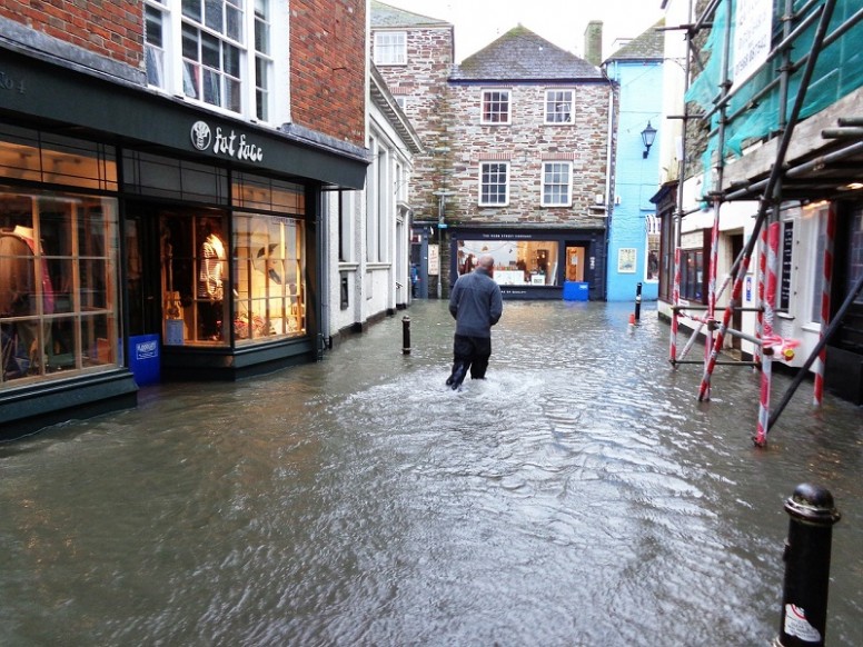
This event saw the worst coastal flooding in south Cornwall since 1962, owing to a combination of a storm surge driven by a southeasterly gale, a “massive” swell, and high spring tides (Eden, 2008). Impacts included closure of roads, delayed trains, fell trees and damaged coastal defences (BBC, 2004). There was also flooding in Dorset and Devon, along with parts of Northern Ireland (Met Office, 2004). In Penzance the combination of spring tides and gale force winds from the southeast sent huge breakers crashing over the Promenade – many properties in the surrounding streets were flooded (West, 2014). There was also 2 ft. [0.6 m] of water on the tracks at Penzance station. At Looe, waves crashing on the front and the rapidly rising tide led to road closures and people being evacuated from their homes into the church hall. The floods caused many roads to be closed to traffic and brought southern parts of the county almost to a standstill. Other affected areas included Fowey, Lamorna, Mousehole, Newlyn, Porthleven, Falmouth, Penryn, Mylor Bridge, Peranarworthal, Devoran and Point, St Mawes, Truro and Tresillian, Goran Haven, Portmellon, Mevagissey and Pentewan, Par, Lostwithiel, Polperro, Seaton and at Kingsand, Torpoint and Saltash. In Fowey 32 properties flooded, 50 flooded in Looe, 40 in Flushing, 40 in Penryn, and 25 in Penzance. At Mousehole, many boats in the harbour were damaged by the extreme waves (Easterling, 2004).
Summary Table
| Loss of life | * |
| Residential property | Around 200 properties were flooded in Cornwall |
| Evacuation & rescue | In Looe, some were evacuated to a local church |
| Cost | * |
| Ports | * |
| Transport | Flooding of the railway at Penzance caused some delay to services. “Many” roads in Cornwall were also flooded |
| Energy | * |
| Public services | * |
| Water & wastewater | * |
| Livestock | * |
| Agricultural land | * |
| Coastal erosion | * |
| Natural environment | * |
| Cultural heritage | * |
| Coastal defences | * |
*No known sources of information available
Affected Sites
| Name | Return Period ? | Water Level ? | Tide ? | Skew Surge ? | Date ? |
|---|---|---|---|---|---|
| NEWLYN | 37 | 6.42 | 5.64 | 0.77 | 27th Oct 2004 16:15 |
| WEYMOUTH | 17 | 2.95 | 2.35 | 0.6 | 27th Oct 2004 18:00 |
| DEVONPORT | 8 | 6.35 | 5.68 | 0.66 | 27th Oct 2004 17:15 |
We rely on submissions from the public to maintain these images. If you witnessed this event, please help by uploading your photos.
References
- Easterling, G. (2004). Mount’s Bay on October 27th 2004 – Storm Surge and Flooding. Available at: http://www.turnstone-cottage.co.uk/PzStorm.PDF (Accessed: 21 October 2015)
- Met Office, (2004). October 2004. Climate Summaries. Available at: http://www.metoffice.gov.uk/climate/uk/summaries/2004/october (Accessed: 30 October 2015].
- Seaview, (n.d.). Seaview Sensing – wave, current and wind data in real time. Available at: http://www.seaviewsensing.com/customers_coastal.html (Accessed: 21 October 2015)
- Eden, P. (2008). Great British Weather Disasters. London: Continuum UK.
- BBC, (2004). ‘Cornwall battles against the storms’. BBC News. Available at: http://www.bbc.co.uk/cornwall/uncovered/stories/october_2004/october_floods.shtml (Accessed: 18 October 2015)
- Met Office, (2004). October 2004. Climate Summaries. Available at: http://www.metoffice.gov.uk/climate/uk/summaries/2004/october (Accessed: 30 October 2015).
- West, I.W. (2014). Chesil Beach -Hurricanes, Storms, and Storm Surges. Geology of the Wessex Coast of Southern England. Available at: http://www.southampton.ac.uk/~imw/chestorm.htm (Accessed: 8 March 2015]


