Storm Event
Stormy seas and flooding on the south coast, particularly in Cornwall
Source
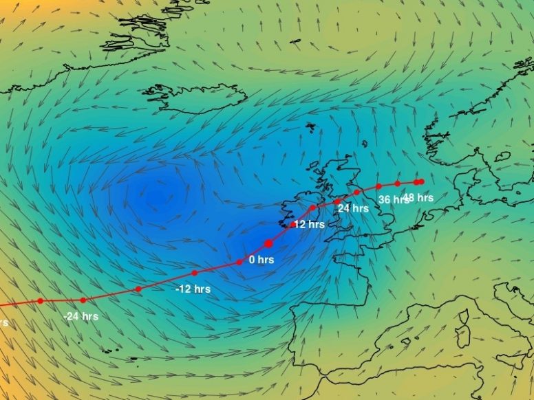
The storm developed over Canada on 4th April and moved eastwards towards the UK. In the middle of the North Atlantic, on 6th April, the storm interacted with a large low-pressure system located nearby to the northwest of Ireland. The storm intensified and central pressures deepened to about 980 mbar. On 7th April, the storm crossed southern Ireland and then northern England and dissipated over the North Sea. Early on 7th April, when the storm was located southwest of Ireland, strong southerly winds blew over the western English Channel and the southwest coast of the UK. Wind gusts of up to 70 knots [36 m/s] were recorded at Gwennap Head, Cornwall (Met Office, 1985).
The storm generated a skew surge of between 0.25 and 0.5 m at many sites in Scotland and along the east and west coast of the UK. Water levels exceeded the 1 in 5 year return level at 3 sites: one in the Bristol Channel and two along the south coast. The highest return period water level was at Newlyn and was 28 years. The 1 in 5 year return level was exceeded twice at Newlyn on consecutive high waters. The next largest return period of 16 years was at Ilfracombe. The highest skew surge was at Newlyn and was 0.47 m, which occurred on the second high water. The event occurred at the time of high spring tides. ‘Stormy seas’ were reported by the (Met Office, 1985).
We are unaware of any sources describing the wave conditions during this event.
Pathway
Other than reports of overtopping at Elmer (near Bognor Regis), we are unaware of any information concerning the flood pathways for this event.
Receptor and Consequence
This event was associated with coastal flooding in Portsmouth, Hayling Island, Eastney and Elmer (near Bognor Regis), and Portchester (Zong and Tooley, 2003). Roads were closed in several places in Hampshire and West Sussex, including the A27 nearby Emsworth (Haigh et al., 2015), where motorists were stranded in water 3 ft. [0.9 m] deep (Ruocco et al., 2011). In Bosham, Portsmouth the conditions were described in one newspaper article as the worst in 20 years (Ruocco et al., 2011). Non-residential and residential properties were flooded in Hythe. The Times (1985) also report the impacts of this event. Bungalows were evacuated at Elmer, near Bognor Regis due to overtopping. A quay flooded in Dartmouth (Environment Agency, 2012). Cornwall Council (2011) reported that an event during April 1985 caused by a combination of high tides and heavy rainfall impacted many locations around the county, which is considered to be in reference to this event. Affected areas included Wadebridge, Padstow, Newquay, Hayle, Mousehole, Flushing, Mevagissey, St Blazey, Fowey, Lostwithiel, Looe, Torpoint and Calstock. This included 25 properties flooded in Hayle, 11 in Fowey, 9 in Looe, 33 in Wadebridge and 35 in Padstow.
According to The Times (1985), four persons were drowned when swept out to sea as vehicles were washed away. We are unaware of any further details regarding the circumstances of these fatalities, and hence this event is classified as a Category 3 only.
Summary Table
| Loss of life | * |
| Residential property | Properties inundated in various locations along the south coast, including over 100 flooded in Cornwall |
| Evacuation & rescue | * |
| Cost | * |
| Ports | * |
| Transport | Roads flooded in many places, including the A27 near Emsworth |
| Energy | * |
| Public services | * |
| Water & wastewater | * |
| Livestock | * |
| Agricultural land | * |
| Coastal erosion | * |
| Natural environment | * |
| Cultural heritage | * |
| Coastal defences | Overtopping was reported at Elmer (near Bognor Regis) |
*No known sources of information available
We rely on submissions from the public to maintain these images. If you witnessed this event, please help by uploading your photos.
References
- Met Office, (1985). Monthly Weather Report of the Meteorological Office. Monthly Weather Report, 102(4). Available at: http://www.metoffice.gov.uk/learning/library/archive-hidden-treasures/monthly-weather-report-1980s
- Zong, Y., and Tooley, M. J. A. (2003). ‘Historical Record of Coastal Floods in Britain: Frequencies and Associated Storm Tracks’. Natural Hazards,29, 13–36. Available at: http://link.springer.com/article/10.1023/A%3A1022942801531 (Accessed: 5 March 2015).
- Haigh, I. D., Wadey, M. P., Gallop, S. L., Loehr, H., Nicholls, R. J., Horsburgh, K., Brown, J. M., and Bradshaw, E., (2015). ‘A user-friendly database of coastal flooding in the United Kingdom from 1915–2014’. Scientific Data, 2, p.150021. Available at: http://www.nature.com/articles/sdata201521.
- Ruocco, A. Nicholls, R. J., Haigh, I. D., and Wadey, M. (2011). ‘Reconstructing Coastal Flood Occurrence Combining Sea Level and Media Sources: A case study of the Solent UK since 1935’. Natural Hazards, 59(3): 1773-1796. Available at: http://link.springer.com/10.1007/s11069-011-9868-7 (Accessed: 27 March 2015).
- The Times, (1985). ‘Four drown as gales and floods cause chaos’. Times Newspapers Limited [London, England]. The Times Digital Archive
- Environment Agency, (2012). South Devon Catchment Flood Management Plan, Exeter. Available at: https://www.gov.uk/government/uploads/system/uploads/attachment_data/file/294030/South_Devon_Catchment_Flood_Management_Plan.pdf
- Cornwall Council, (2011). Preliminary Flood Risk Assessment ANNEX 5 – Chronology of Major Flood Events in Cornwall, Truro


